Embraer integrates space systems and develops satellites, remote sensing products and services, satellite telecommunications and SAR aerial surveys in the X P Bands. The company operates in this segment through its subsidiary company Visiona Space Technology.

The satellite is equipped with a high-resolution space camera capable collecting radiometric and geometric pictures with quality exceeding market standards, making it ideal for taking for agricultural and environmental applications.
VCUB is also equipped with a UHF data collection system powered by software-defined radio. Its architecture is extremely flexible, and the system is driven initially for collecting hydrological and meteorological data, but could also be dated post-launch to include other IoT applications as needed.
In October 2018, Visiona announced it completed the development of its Altitude and Orbit Control System (AOCS), which is responsible for satellite navigation, pointing, and control. This unique system is what allows a satellite, for example, to accurately point its camera to where images need to be collected or activate its propulsion mechanisms to correct its desired orbit.
Navigation: Determines satellite statuses using sensor measurements.
Guidance: Calculates the desired altitude (direction) for the satellite (target on land)
Control: Determines actuator commands in order to find the desire altitude.
On-Board Data Handling (OBDH) is the satellite’s primary management and command software. As the satellite’s “brain”, it’s responsible.
VCUB’s Unique Features
The program helped establish Visiona as an integrator of Brazilian satellites, having the expertise to become Brazil’s industrial right arm for designing and developing space solutions.
The satellite will bring broadband internet connection to all territories in Brazil, promoting digital and social inclusion to millions of citizens.
The satellite is the ideal means of ensuring complete coverage in a continental nation like Brazil, complementing today’s fiber optics structures that may not be capable of providing services to all Brazilian cities. SGDC will also ensure secure strategic and defensive communications for Brazil.
Moreover, the program has already trained over 30 engineers, allowing them to work with state-of-the-art tech in terms of satellite development and manufacturing.
Visiona, Telebras, the Ministry of Defense, the Brazilian Space Agency, and INPE, the entities participating in the SGDC program, are qualified to work with state-of-the-art geostationary satellite development and design technologies. Approximately 30 engineers worked side by side with Thales, the satellite manufacturer, over the course of the program and throughout all of its phases, from conception to the final acceptance tests.
LAUNCH AND ORBIT
Launcher: Ariane 5 ECA
Launch Base: Kourou, French Guiana
Orbit: Geostationary
Position: 75°W
SOLO SEGMENT
TT&C Centers: 1+1
Gateways: 4+1
PLATAFORM
Model: Spacebus 4000 C4
Width: 37 m
Height: 7 m
Weight: 5.8 tons
Power: 11 kW
Lifespan: 18 years
PAYLOAD
Ka and X bandwidth coverage: National
No. of Ka Bandwith Beams: 67
Ka Bandwidth Capacity: 58 Gbps
Arianespace’s Ariane 5 is a global reference among major launchers. Thanks to its high degree of precision in its missions, Ariane 5 can transport useful loads exceeding 10 tons for geostationary orbits (GTO) and over 20 tons for low-elevation orbits (LEO). This degree of performance ensures Ariane 5’s high rate of efficiency for telecommunications satellites.
The Ariane 5 rocket has 98.7% reliability with an impressive 75 successful launches. Visit Ariane 5’s official website.
75 successful missions (all in French Guiana).
Two-passenger capacity for the Ariane 5 launcher
Airbus Launchers SAFRAN Main Contractor
5.4m in Diameter
50.5m in Height
780t in Mass
10t load for GTO
20t load for LEO


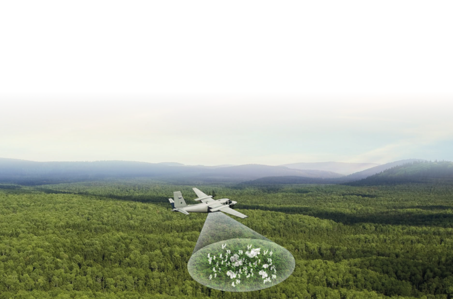
The Embraer SAR3000, with Dual Band (one for above and one for under the forest canopy), provides a complete view of activities in forest lands, even those hidden under the cover of trees. It also offers change detection capability for continuous monitoring through a software feature that automatically compares multiple readings of a location.
The interferometric synthetic aperture radar in the X and P Bands guarantees the delivery of geographic information of high added value and high cost-benefit for different applications.

Multi-Mission

Multi-Mission


-

-

-

-

-

-
Comprised of 64 optic sensors and 13 radar sensors, the constellation can offer integrated remote sensor products with high revisiting and image generation rates. These sensors with complementary characteristics represent the global state-of-the-art, capable of achieving 30-cm resolutions and making up Brazil’s most comprehensive collection of high-resolution images.
The constellation’s radar satellites, operating in the X and L ranges (the latter being the sole orbital platform technology in the world), allow you to observe even through clouds and play an important role in environmental monitoring projects.
Visiona leverages its technical team of highly qualified professionals, including some with Master’s and Doctorate Degrees, to offer consultancy services for remote sensor and geoprocessing projects, bringing together technical know-how on information transformation to drive decision-making.
The digital image processing (DIP) services aim to identify and extract information from images to improve the quality of data both when it comes to precision and to visualizing targets of interest. This procedure complements and implements corrections that satellites may not be able to provide with raw images.
The key processes carried out with DIP are:
Visiona works with its partners to develop products and services with high aggregate value, using images collected daily by a constellation of optical satellites and SAR (Synthetic Aperture Radar), with the goal of providing services to governments (federal, state, and local) and private entities from a number of sectors, including:

-

-

-

-

-

-

-

-

-
The WebVis Platform provides users with access to on-demand remote sensor images, including the most recent satellite images with the highest spatial resolutions in the world. By subscribing to this service, users will have access to images collected by a variety of sensors with different resolutions and from different providers. Users may also choose between streaming and downloading images according to their needs.
Below each satellite are the spatial resolutions of the images found on WebVis.

Customize or upload from your area of interest in a number of different formats.
View your image in full resolution before downloading.
Highly reliable base map, allowing you to choose your area of interest precisely and securely.
Monitor your areas of interest and plan your next actions using recent, highly reliable images.
Access images with spatial resolutions of 30 cm x 30 m collected by commercial and government satellites.
Available in streaming and download versions. Please contact our sales team to learn more about pricing options.

 CLOSE
CLOSE
 CLOSE
CLOSE
 View all sections